Self drive 4wd hire information on
the Gibb River Road
|
||||||
|
Gibb River Road Companies such as Australia4wheel Drive Rentals offer you a choice of 4wd Poptop Campers for 2 persons or a Landcruiser with a roof top tent that sleep 2 and a ground side annexe that sleeps 3 on mattresses. Yes these companies supply the bedding and cooking equipment most include it in their daily basic rental. We recommend a minimum of 10 to 14 days to do a road trip from Darwin to broome on the Gibb River road. below are approximate distances to travel.
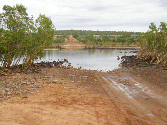
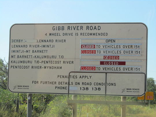
The Gibb River Road in Western Australia back in the old days was initially constructed as a beef road to transport cattle from the surrounding stations to the ports of Derby and Wyndham. It spans some six-hundred and seventy kilometres from Derby to the junction of the Great Northern Highway between Wyndham and Kununurra in Western Australia. The Gibb River Road travels some six-hundred and seventy kilometre through the central Kimberley Plateau from King Sound at Derby to the Cambridge Gulf at Wyndham. The whole road is now the responsibility of Main Roads WA and improvements to creek crossings and jump ups are being made every year. The majority of the road surface is of dirt and gravel construction with only some floodways paved. The road can be very corrigated in sections and rough. The Gibb River Road traditionally opens late April till early decemeber and then offically closes. A grader from Derby and another from Kununurra need to grade the road after each wet season which is traditionally speaking November till April. Often when you look at the Roads WA website. The offical Roads WA website states: Note that during the wet season (Nov-Apr) conditions change rapidly, caution must be exercised at all times. Floodways and creek crossings may rise and fall without notice. In the wet season (this article was written 09.03.2016)
WA Roads list numerous warnings - with examples as follows.
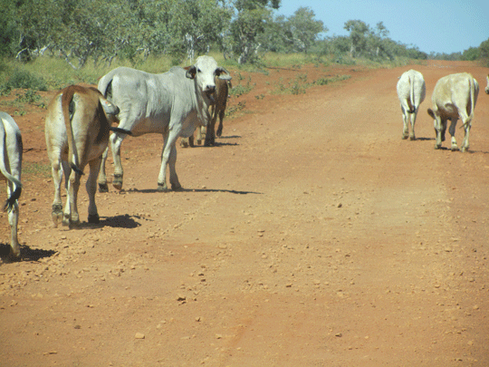
When can I begin to travel on the Gibb River Road? A question asked most of the time. Now the weather pattern traditionally suggests may 1 but the road must be open safe and passable for 4wd hire companies in Darwin and Broome to let the 4wd hire go on the Gibb then. Passable means are the rivers like the Penecost and the Durrack low enough to cross. The hire 4wd car companies get a WA roads report every morning updating them. ANother mention is mMotorists should be aware of fauna and wandering stock on and near all roads in the Kimberley Region. Drive with caution particularly in the hours between dusk and dawn. We recommend the use of high clearance robust vehicles, preferably 4WD, for DRY season (May to October) travel. Towing of any type is not recommended. However, well constructed off road trailers may survive the often corrugated conditions in the DRY. Caravans are definitely NOT recommended. There are excellent 4wd and 4wd camper trailer packages available but heavily booked out for most of 2016 and even now in 2017. Wet season (November to April) travel can be severely restricted by flooding and road closures as the countryside can become very waterlogged. Access to the gorges is very often not possible and, if travel occurs, is restricted to the Gibb River Road itself and not to the sidetracks into the gorges. A 4WD vehicle equipped with a snorkel is essential once the rains have started. Travellers in breach of official Road Closure and Road Restrictions are subject to fines. So with the small window frame to travel each year we suggest your search for your 4wd camper rental as early as Septemeber the year before. |
||||||
|
About the Kimberley The Kimberley in Australia is one of the last true wilderness areas on Earth, with rustic unique outback landscapes and landmarks billions of years in the making. Covering app 423,000 square kilometres in north Western Australia and with a population of less than 40,000 people, it�s here you�ll encounter some of the most extraordinary outback adventuresand folks in Australia. Discover ancient gorge country with hikes and trekking a must in planning your Kimberley vacation to enormous cattle stations, pristine coastline and sandy beaches, to one of the oldest cultures on the planet and the world�s only horizontal waterfalls. |
||||||
|
|
||||||
 |
||||||
|
About the Gibb River Road |
||||||
|
Western Australia and National Parks (WA) towns, rivers, roads, crossings, stopovers and places of interest (WA) Folks I'm adding more infor soon in the
meantime for all your Kimerley Info please go to Darwin
to Broome Mitchell Plateau Region
|
||||||
|
|
||||||
 |
||||||
![]()
![]()
-
 Broome to Darwin 4wd Adventure Camper rental
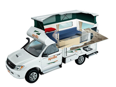
2 Berth - The compact Adventure Camper is perfect for those interested in a real outback adventure. Far roomier than similar vehicles, this 4WD campervan is ideal for thrill seeking couples. The extra fuel capacity means you can travel for longer without having to stop and the indoor and outdoor cooking facilities allows you to enjoy a dinner under the stars or in the cosy camper.
� Apollo 4wd Adventure rental details -
 Darwin 4wd rooftop tent camper hire
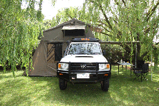
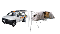
Our 4WD Campers can go on most remote 4WD unsealed dirt road tracks being allowed to travel to tourism iconic destinations, they seat/sleep up to 5 people, with 2 above in the pop up roof top tent, and sleeping for 3 in the annex on 3 single foam/blowup mattress's. With basic 4WD essentials such as fridge/freezer, 2 burner gas stove and air conditioned drivers cabin this 4x4 camper..
� Darwin 4wd rentals to Broome Australia details -
 Darwin 4wd poptop camper rental
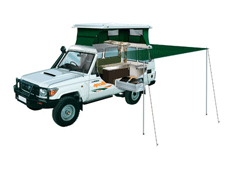
Find your own trail with this pop-top 4WD Camper. A Trailfinder Camper is ideal for adventurous couples with superior handling in rough terrain. Featuring a large slide-out kitchen and pop top roof. This 4wd rental is for those who wish to sleep inside and not outside on the ground but wish to cook outside the best of both worlds.
� Apollo 4wd Trailfinder camper rental Australia details
-
 Darwin 4x4 wagon offroad hire
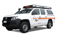
Choose a Australian 4 wheel drive car hire return or oneway rentals from branches in Adelaide, Alice Springs, Brisbane, Broome, Cairns, Darwin, Melbourne, Perth and Sydney depots. � Our range consists Amarok or Toyota Landcruiser 76 series Workmate Wagon or similar options. Look at our current Australia 4wd hire specials.
� See prices and get a quote for Australia 4wd car hire here
-
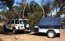
Darwin 4x4 camper trailer hireDon�t have a 4WD but want to go bush? We have come up with a perfect package. This package is also available in Darwin during the dry season from May to August each year. Other times of the year will depend on demand and circumstance, however feel free to call us to find out how we can help you plan your Northern Australian Adventure.
� Darwin 4wd camper trailer hire Australia
-
 Broome to Darwin 4x4 hire
5 Seat 4WD Campers or 4WD Car with ground tents packages for camping hire called the four wheel drive hire Safari Camper sleeps up to 5 Adults with camping gear. Excellent setup camp early eve and enjoy the great outdoor and have your dinner at a 5 million star spot.
� See prices and get a quote for Australia 4wd car hire here